Introduction
Weather is one of the most important factors in aviation. It affects aircraft performance, visibility, passenger comfort, fuel planning, airport operations, and the overall safety of a flight.
Pilots have traditionally relied on weather reports, forecasts, radar images, airport observations, and information from air traffic services. These sources remain essential, but modern technology is making aviation weather information easier to collect, compare, and understand.
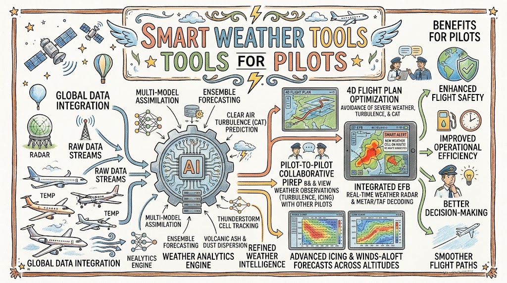
Smart weather tools combine artificial intelligence, satellite data, radar information, aircraft observations, and predictive models. They help pilots identify possible hazards, understand changing conditions, and compare different flight options.
These tools do not replace aviation weather knowledge or pilot judgment. They support better decisions by presenting important information in a timely and practical way.
What Are Smart Weather Tools?
Smart weather tools are digital systems that collect, process, and present weather information for pilots and aviation professionals.
Unlike a basic weather forecast, a smart tool may combine several information sources into one operational view.
It can help pilots assess:
- Wind speed and direction
- Cloud height and coverage
- Visibility
- Thunderstorms
- Lightning
- Turbulence
- Icing
- Rain or snow
- Atmospheric pressure
- Temperature
- Runway conditions
- Weather along the planned route
Some tools also use artificial intelligence to recognise patterns, predict short-term changes, and warn users when conditions may become unsafe.
Why Pilots Need Reliable Weather Tools
Weather can change rapidly. Conditions at departure may be safe while the destination or route becomes unsuitable later.
A pilot must understand not only the current weather but also how it may develop during the flight.
Reliable weather tools help pilots:
- Plan safer routes
- Choose suitable altitudes
- Calculate fuel requirements
- Select alternate airports
- Avoid thunderstorms
- Prepare for turbulence
- Assess crosswind conditions
- Identify icing risk
- Decide whether to delay or cancel a flight
- Monitor weather after departure
Good weather decisions reduce unnecessary risk and prevent pilots from being surprised by conditions that could have been identified earlier.
Traditional and Smart Weather Tools
Traditional aviation weather products remain the foundation of flight planning. Smart tools improve the way these products are organised and interpreted.
| Traditional Weather Source | Smart-Tool Enhancement |
|---|---|
| Airport weather report | Trend analysis and operational risk alerts |
| Aviation forecast | Route-specific weather interpretation |
| Weather radar | Storm tracking and movement prediction |
| Satellite imagery | Automated cloud and storm recognition |
| Pilot reports | Real-time turbulence and icing mapping |
| Wind forecast | Fuel and route optimisation |
| Weather warnings | Personalised alerts for specific flights |
The smartest system is not necessarily the one with the most features. It is the one that provides clear, reliable, and relevant information without creating confusion.
Aviation Weather Briefing Platforms
Weather briefing platforms bring several weather products into a single digital environment.
A pilot may use them to review:
- Departure conditions
- Destination conditions
- Alternate airport weather
- Route forecasts
- Significant weather charts
- Winds at altitude
- Weather warnings
- Notices affecting the flight
- Radar and satellite images
Smart briefing platforms can organise this information according to the planned route and departure time.
Instead of searching through unrelated reports, the pilot receives a focused weather picture for the specific flight.
Digital Weather Radar Tools
Weather radar is one of the most useful tools for identifying precipitation and thunderstorm activity.
Digital radar platforms can display:
- Rain intensity
- Storm location
- Storm movement
- Cell development
- Severe weather areas
- Lightning activity
- Estimated arrival time of storms
Advanced tools analyse radar images over time and estimate where a storm may move next.
Pilots should remember that radar images may be delayed and cannot show every hazard. A gap between storm cells may also close before an aircraft reaches it.
Radar must be used with weather reports, forecasts, onboard equipment, and safe thunderstorm-avoidance procedures.
Satellite Weather Imagery
Satellites provide a broad view of cloud systems, storms, moisture, and atmospheric movement.
Satellite tools are useful for understanding:
- Cloud coverage
- Large storm systems
- Tropical weather
- Frontal movement
- Fog development
- Dust and smoke
- Weather over areas with limited ground radar
Artificial intelligence can analyse satellite images and identify developing cloud patterns.
This may help pilots recognise areas where thunderstorms or poor visibility are likely to form.
Satellite imagery is especially valuable during long-distance flights and operations over oceans, mountains, or remote regions.
Smart Wind Forecasting Tools
Wind affects every phase of flight.
Pilots must consider:
- Headwinds
- Tailwinds
- Crosswinds
- Wind gusts
- Wind shear
- Winds at altitude
- Mountain waves
- Local terrain effects
Smart wind tools can show expected wind speed and direction at different altitudes and locations.
They can help pilots compare routes and cruising levels. A route with favourable winds may reduce flight time and fuel use, while strong headwinds may require additional fuel.
Near airports, short-term wind predictions can help pilots prepare for runway changes or difficult landing conditions.
Crosswind Calculation Tools
Crosswind is the part of the wind acting across the runway.
Pilots must compare the expected crosswind with:
- Aircraft limitations
- Pilot experience
- Runway condition
- Wind gusts
- Company procedures
- Local operating requirements
Digital crosswind calculators can quickly estimate headwind, tailwind, and crosswind components.
These tools are useful, but pilots should still understand how the calculation works. They must also consider that wind may change between the weather report and the actual landing.
A calculated value should support judgment rather than replace it.
Turbulence Forecasting Tools
Turbulence can affect aircraft control, passenger comfort, and cabin safety.
Smart turbulence tools may combine:
- Jet-stream information
- Atmospheric stability
- Wind-speed changes
- Mountain-wave forecasts
- Pilot reports
- Aircraft sensor data
- Satellite observations
- Historical turbulence patterns
Some systems create route-specific turbulence maps. These maps help pilots and dispatchers identify smoother altitudes or alternative routes.
Early turbulence information also gives cabin crews more time to secure equipment and prepare passengers.
However, turbulence forecasts are estimates. Conditions may be stronger, weaker, or located differently from the forecast.
Icing Prediction Tools
Aircraft icing can occur when supercooled water droplets freeze on aircraft surfaces.
Icing may affect:
- Lift
- Drag
- Aircraft weight
- Propeller efficiency
- Engine performance
- Sensors
- Control surfaces
Smart icing tools analyse temperature, moisture, cloud type, precipitation, altitude, and pilot reports.
They may show areas with possible light, moderate, or severe icing.
Pilots can use this information to avoid hazardous altitudes, select a different route, or delay the flight.
The tool must always be used together with aircraft certification, anti-icing equipment, operating procedures, and current weather observations.
Lightning Detection Systems
Lightning detection tools identify electrical activity in and around thunderstorms.
They can help pilots understand:
- Where active storm cells are located
- Whether a storm is becoming stronger
- How quickly the system is moving
- Whether airport ground operations may be affected
- Whether a planned route passes near dangerous convection
A high rate of lightning activity may indicate a powerful and rapidly developing storm.
Lightning information is most useful when combined with radar and satellite imagery. It should never be used alone to determine that an area is safe.
Wind-Shear Alerting Tools
Wind shear is a sudden change in wind speed or direction over a short distance.
It is particularly dangerous during:
- Takeoff
- Initial climb
- Approach
- Landing
Modern airports may use ground-based wind-shear detection systems. Aircraft may also carry onboard warning equipment.
Smart systems can combine airport sensors, radar, wind data, and aircraft reports to identify developing wind shear.
Pilots may receive alerts that allow them to delay departure, discontinue an approach, or perform a go-around.
Wind-shear warnings should always be treated seriously and handled according to approved procedures.
Visibility and Fog Forecasting Tools
Low visibility can affect departure, approach, landing, and taxi operations.
Smart forecasting tools can help predict:
- Fog formation
- Fog clearance
- Low clouds
- Heavy rain
- Dust
- Smoke
- Snow
- Runway visual range
Artificial intelligence can study local patterns involving temperature, humidity, wind, terrain, and nearby water.
This is useful because fog may behave differently at every airport.
A more accurate short-term visibility forecast helps pilots decide whether a destination or alternate airport is likely to remain suitable.
Route-Based Weather Planning Tools
Route-based tools display weather directly along a planned flight path.
Instead of reviewing a large regional map, the pilot can focus on the areas and times relevant to the flight.
These tools may show:
- Weather at departure
- Conditions along the route
- Weather at planned cruising levels
- Destination forecasts
- Alternate airport conditions
- Thunderstorm locations
- Turbulence zones
- Icing risk
- Wind changes
- Restricted weather areas
The tool may also compare alternative routes and departure times.
A route-based view can reduce information overload, but pilots should still review the wider weather situation in case conditions change.
Electronic Flight Bag Weather Tools
Electronic flight bags have become important tools in modern cockpits.
An electronic flight bag may provide access to:
- Charts
- Flight plans
- Weather reports
- Radar images
- Airport information
- Performance calculations
- Operational documents
Weather applications integrated into an electronic flight bag allow pilots to review updated conditions before and during flight.
Important considerations include:
- Battery level
- Device temperature
- Internet or data connection
- Software updates
- Screen visibility
- Backup equipment
- Approved operational use
Pilots should know which functions are officially approved and which are only supplementary.
AI-Powered Weather Assistants
AI-powered assistants can make complex weather information easier to understand.
A pilot may receive a summary such as:
- Strong crosswinds expected at arrival
- Moderate turbulence likely during descent
- Thunderstorms developing near the planned route
- Destination visibility expected to fall below limits
- Alternate airport weather improving
- Additional fuel may be required for rerouting
This type of summary can save time, but it must include the source, issue time, forecast confidence, and important limitations.
Pilots should not accept an AI-generated summary without reviewing the supporting weather information.
Real-Time Aircraft Weather Data
Aircraft collect valuable atmospheric data during flight.
Depending on the system, this may include:
- Temperature
- Wind speed
- Wind direction
- Air pressure
- Turbulence
- Aircraft movement
- Icing indications
When information from many aircraft is combined, it creates a more detailed view of current conditions.
Smart platforms can use this data to update turbulence maps, wind forecasts, and route recommendations.
Real-time aircraft observations are especially useful in areas where weather stations or radar coverage are limited.
Mobile Weather Applications for Pilots
Mobile weather applications are convenient for planning and monitoring, especially in general aviation.
A useful application may offer:
- Airport weather
- Aviation forecasts
- Radar
- Satellite imagery
- Wind information
- Weather warnings
- Route planning
- Saved airports
- Personal alerts
Pilots should verify whether the application uses official aviation data and how often it updates.
A visually attractive app is not automatically an approved or reliable source.
Before using a mobile tool operationally, pilots should understand:
- Data origin
- Update frequency
- Coverage limitations
- Delay in radar images
- Offline availability
- Legal or regulatory acceptance
Smart Weather Alerts
Smart alert systems notify pilots when conditions reach selected limits.
Alerts may be created for:
- Crosswind speed
- Visibility
- Cloud ceiling
- Thunderstorms
- Lightning
- Icing
- Turbulence
- Heavy precipitation
- Destination weather changes
Personalised alerts can reduce the need for constant manual checking.
However, pilots should not rely only on notifications. A delayed alert, software problem, or lost connection may prevent an important warning from appearing.
Active weather monitoring remains necessary.
Choosing the Right Weather Tool
Pilots should evaluate weather tools carefully.
Important questions include:
- Does it use recognised aviation weather data?
- How frequently is the information updated?
- Does it show the observation or forecast time?
- Does it explain forecast uncertainty?
- Can the pilot review the original weather report?
- Does it work without an internet connection?
- Is it approved for operational use?
- Does it provide route-specific information?
- Are alerts easy to understand?
- Is there a reliable backup?
The best tool supports the pilot’s workflow without hiding important details.
Benefits of Smart Weather Tools
Faster Weather Analysis
Pilots can compare several weather sources in one place.
Better Hazard Awareness
Smart systems highlight storms, icing, turbulence, fog, and strong winds.
Improved Route Planning
Pilots can compare routes, altitudes, and departure times.
Better Fuel Planning
More accurate wind and weather information supports fuel calculations.
Earlier Decisions
Pilots may delay, reroute, or cancel a flight before conditions become critical.
Reduced Workload
Clear summaries and alerts can reduce the time needed to review large amounts of information.
Improved Passenger Safety
Early warnings allow pilots and cabin crews to prepare for difficult conditions.
Limitations of Smart Weather Tools
Smart tools are helpful, but they are not perfect.
Delayed Information
Radar, satellite, and aircraft data may not be fully real time.
Forecast Errors
Weather may develop differently from the prediction.
Data-Connection Problems
A tool may stop updating when network coverage is lost.
Poor Data Quality
Incomplete or incorrect information can reduce reliability.
Overdependence
Pilots may trust a digital recommendation without performing independent analysis.
Information Overload
Too many layers, alerts, and colours can make decisions more difficult.
Limited Explainability
Some AI tools may not clearly explain why they generated a warning.
Avoiding Automation Bias
Automation bias occurs when a person trusts a computer-generated recommendation too quickly.
A pilot may accept a route as safe simply because the application displays no warning.
To reduce this risk, pilots should:
- Compare multiple weather sources.
- Check the issue time of every product.
- Review original reports.
- Consider the wider weather pattern.
- Look for missing or outdated data.
- Question unexpected recommendations.
- Maintain independent decision-making skills.
- Prepare a backup plan.
The absence of an alert does not prove that no hazard exists.
Smart Tools and Pilot Weather Training
Smart technology is most useful when the pilot understands aviation meteorology.
Training should cover:
- Weather reports and forecasts
- Cloud types
- Thunderstorm hazards
- Wind and pressure
- Visibility
- Fog
- Turbulence
- Icing
- Weather radar interpretation
- Satellite imagery
- Forecast uncertainty
- AI limitations
- Automation bias
- Flight decision-making
Student pilots should learn the underlying weather concepts before depending on automated summaries.
Technology changes, but strong weather knowledge remains essential.
A Smart Weather Planning Process
Review the Wider Weather Situation
Understand fronts, pressure systems, storms, and regional hazards.
Check Departure Conditions
Review wind, visibility, cloud, precipitation, runway conditions, and warnings.
Analyse the Route
Identify thunderstorms, turbulence, icing, terrain effects, and strong winds.
Review Destination and Alternate Airports
Check whether conditions are expected to remain above required limits.
Compare Forecast Times
Make sure weather information covers the expected departure and arrival periods.
Use Smart Alerts and Risk Summaries
Review automated warnings, confidence levels, and recommended alternatives.
Verify Important Information
Compare the smart-tool output with recognised aviation weather sources.
Prepare Alternatives
Plan different routes, altitudes, airports, and departure times.
Continue Monitoring
Update the weather picture before departure and throughout the flight.
Future of Smart Weather Tools
Future aviation weather tools are likely to become more personalised and predictive.
Possible developments include:
- Flight-specific weather risk scores
- Minute-by-minute airport forecasts
- More accurate turbulence maps
- Automated alternate-airport recommendations
- AI cockpit weather assistants
- Better local wind prediction
- Connected aircraft weather sharing
- Augmented-reality weather displays
- Drone weather guidance
- Digital twins of airport weather environments
Future systems may explain not only what weather is expected but also how it may affect a particular aircraft and flight.
Safety will depend on transparent predictions, reliable data, human oversight, and strong pilot training.
Best Practices for Pilots
Pilots using smart weather tools should:
- Use recognised aviation weather sources.
- Check when each product was issued.
- Compare several information sources.
- Understand the tool’s limitations.
- Review forecast confidence.
- Keep backup weather access available.
- Set realistic personal operating limits.
- Avoid continuing a flight because of schedule pressure.
- Monitor weather throughout the flight.
- Treat AI as support, not authority.
- Follow approved procedures and regulations.
- Make conservative decisions when uncertain.
Frequently Asked Questions
What are smart weather tools for pilots?
They are digital systems that combine aviation weather information, forecasts, alerts, and predictive analysis to support safer flight planning and decision-making.
Can pilots rely completely on weather applications?
No. Applications should support official weather information, pilot knowledge, approved procedures, and independent judgment.
How does AI improve aviation weather tools?
AI analyses large amounts of weather data, recognises patterns, predicts short-term changes, and highlights hazards relevant to a specific flight.
Are mobile weather apps safe for flight planning?
They can be useful when they use reliable data and are appropriate for the intended operation. Pilots must understand their limitations and regulatory status.
Can smart tools predict turbulence?
They can estimate turbulence probability using wind, temperature, aircraft data, pilot reports, and atmospheric models. Predictions are not always exact.
How do weather tools help with crosswinds?
They provide wind forecasts and may calculate headwind, tailwind, and crosswind components for a selected runway.
Can smart weather systems detect icing?
They can identify areas where icing is possible by analysing temperature, moisture, clouds, precipitation, and pilot reports.
Why must pilots check the weather issue time?
Old information may not reflect current conditions. Pilots must know when an observation, forecast, radar image, or alert was produced.
Do smart weather tools replace pilot training?
No. Pilots need strong meteorological knowledge to understand the information, identify errors, and make safe decisions.
What is the biggest risk of using automated weather tools?
One major risk is automation bias, where a pilot trusts a recommendation without checking the underlying data or considering other evidence.
Conclusion
Smart weather tools help pilots collect, organise, and understand important weather information. They support better route planning, hazard identification, fuel preparation, and in-flight decision-making. However, even the most advanced tool cannot replace aviation knowledge, approved procedures, or professional judgment. Safe pilots use intelligent technology as one part of a complete and carefully verified weather decision process.