Introduction
Weather is one of the most important subjects for aviation students. Every flight takes place within the atmosphere, where wind, temperature, pressure, clouds, visibility, precipitation, and storms can affect aircraft performance and safety.
Learning weather theory is essential, but modern aviation students must also understand how to analyse weather data. Weather analytics turns observations, forecasts, radar images, satellite information, and aircraft reports into practical flight decisions.
It helps students answer important questions:
- Is the weather suitable for the planned flight?
- Which hazards may develop along the route?
- Will the destination remain safe at the expected arrival time?
- Is an alternate airport necessary?
- Should the flight be delayed, rerouted, or cancelled?
- How could wind affect flight time and fuel consumption?
Artificial intelligence and digital aviation tools can process large volumes of weather data quickly. However, students must understand the information behind the recommendations. Technology should support aviation knowledge rather than replace it.
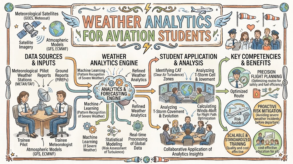
What Is Weather Analytics in Aviation?
Weather analytics is the process of collecting, comparing, and interpreting atmospheric data for aviation use.
It combines information from multiple sources, including:
- Airport weather observations
- Aviation forecasts
- Weather radar
- Satellite imagery
- Wind forecasts
- Pilot reports
- Lightning detection systems
- Atmospheric models
- Aircraft sensor data
- Historical weather records
The purpose is to identify conditions that may affect a flight.
A basic forecast may show expected wind and visibility. Weather analytics goes further by comparing that forecast with the aircraft, route, runway, altitude, departure time, and destination.
It transforms weather information into operational meaning.
Why Aviation Students Need Weather Analytics
Aviation weather is rarely simple. Several conditions may exist at the same time, and the forecast may change before or during a flight.
For example, a student may see acceptable weather at departure but discover:
- Strong winds near the destination
- Thunderstorms developing along the route
- Visibility expected to decrease before arrival
- Turbulence at the planned cruising altitude
- Icing risk inside clouds
- An unsuitable alternate airport
Weather analytics teaches students to examine the complete flight rather than a single weather report.
It also improves:
- Situational awareness
- Flight-planning ability
- Hazard recognition
- Fuel planning
- Alternate-airport selection
- In-flight decision-making
- Risk management
- Aviation safety
A student who understands weather analytics is better prepared to make conservative and informed decisions.
Main Sources of Aviation Weather Data
Airport Weather Observations
Airport observations describe the current conditions at or near an airport.
They normally include:
- Wind direction and speed
- Visibility
- Weather phenomena
- Cloud height and coverage
- Temperature
- Dew point
- Atmospheric pressure
- Significant recent weather
Students should learn to identify whether the observation is recent enough to support the planned decision.
A report describes conditions at a particular time. It does not guarantee that the same weather will exist later.
Aviation Weather Forecasts
Forecasts describe the weather expected during a future period.
They may include:
- Expected wind
- Visibility
- Clouds
- Rain or snow
- Thunderstorms
- Fog
- Temporary conditions
- Probable changes
Students must compare forecast validity with the planned departure and arrival times.
A forecast that ends before the estimated arrival time may not provide enough information for safe planning.
Weather Radar
Weather radar helps identify precipitation and storm activity.
Radar may show:
- Rain intensity
- Storm-cell location
- Movement direction
- Changes in intensity
- Areas of heavy precipitation
Radar is useful for thunderstorm awareness, but it has limitations. Images may be delayed, coverage may vary, and some hazards may not be clearly visible.
Students should never treat a gap between intense storm cells as automatically safe.
Satellite Imagery
Satellite imagery provides a wider view of cloud systems and atmospheric movement.
It can help students identify:
- Large cloud areas
- Developing storms
- Tropical systems
- Frontal movement
- Fog
- Smoke
- Dust
- Weather over remote areas
Satellite information is particularly useful when ground-based radar coverage is limited.
Pilot Weather Reports
Pilot reports provide observations from aircraft already operating in the atmosphere.
They may contain information about:
- Turbulence
- Icing
- Cloud layers
- Visibility
- Wind
- Temperature
- Weather conditions
These reports can add valuable real-world information to forecasts.
However, students should consider the aircraft type, altitude, reporting time, and location. Conditions affecting one aircraft may not affect another in exactly the same way.
Important Weather Variables for Students
Wind
Wind affects takeoff, landing, route planning, aircraft speed, and fuel consumption.
Students should analyse:
- Surface wind
- Crosswind
- Headwind
- Tailwind
- Wind gusts
- Upper-level wind
- Wind shear
- Mountain waves
A strong headwind may increase flight time and fuel use. A tailwind may reduce travel time but create runway limitations during landing.
Crosswind must be compared with aircraft limitations, runway conditions, pilot experience, and training requirements.
Visibility
Visibility affects visual navigation, takeoff, approach, landing, and airport operations.
Poor visibility may result from:
- Fog
- Heavy rain
- Snow
- Dust
- Smoke
- Haze
- Low clouds
Students should not look only at current visibility. They must assess whether it is expected to improve or deteriorate.
Cloud Base and Coverage
Cloud conditions influence visual flight operations, instrument approaches, turbulence, icing, and visibility.
Students should understand:
- Cloud height
- Cloud coverage
- Cloud type
- Vertical development
- Expected changes
Towering clouds and rapidly growing formations may indicate unstable conditions and possible thunderstorm development.
Temperature and Dew Point
Temperature affects aircraft performance, while the difference between temperature and dew point provides information about atmospheric moisture.
When temperature and dew point are close, fog or low cloud may be more likely.
High temperatures can also reduce air density, increase takeoff distance, and reduce climb performance.
Atmospheric Pressure
Pressure information is important for altimeter settings, weather-system analysis, and aircraft performance.
Falling pressure may indicate an approaching low-pressure system or deteriorating weather. Rising pressure may be associated with improving conditions, although local factors must still be considered.
Precipitation
Rain, snow, freezing rain, and hail can affect:
- Visibility
- Runway braking
- Aircraft performance
- Icing risk
- Radar interpretation
- Ground operations
Students must understand that precipitation intensity and type may change quickly.
Using Analytics to Identify Weather Hazards
Thunderstorms
Thunderstorms can contain:
- Severe turbulence
- Lightning
- Hail
- Heavy rain
- Strong vertical currents
- Wind shear
- Microbursts
- Icing
- Reduced visibility
Weather analytics can combine radar, satellite, lightning, wind, temperature, and moisture data to show where storms may develop or move.
Students should use analytics to support avoidance, not to find a path through dangerous storm activity.
Turbulence
Turbulence may occur near:
- Thunderstorms
- Mountains
- Jet streams
- Fronts
- Strong wind changes
- Unstable air
Analytics can compare wind gradients, atmospheric stability, terrain, aircraft reports, and forecast models.
Students can use this information to choose a more suitable route or altitude and prepare for possible changes.
Aircraft Icing
Icing risk depends on temperature, moisture, clouds, precipitation, altitude, and aircraft capability.
Weather analytics may identify regions where icing is more likely.
Students must compare this information with:
- Aircraft certification
- Anti-icing and de-icing equipment
- Pilot experience
- Route options
- Escape plans
The presence of approved equipment does not make all icing conditions acceptable.
Wind Shear
Wind shear is a rapid change in wind speed or direction.
It is particularly dangerous during:
- Takeoff
- Initial climb
- Approach
- Landing
Analytics can combine airport sensors, radar, wind reports, and previous aircraft observations to identify possible wind-shear conditions.
Students should understand warning procedures and know when a departure, approach, or landing should be delayed or discontinued.
Fog and Low Clouds
Fog can form and disappear quickly.
Analytics can compare:
- Temperature
- Dew point
- Wind
- Moisture
- Terrain
- Nearby water
- Historical patterns
This helps students understand whether visibility may improve or deteriorate before the planned arrival.
Weather Analytics in Pre-Flight Planning
Before departure, students should develop a complete weather picture.
A structured analysis should include:
Departure Airport
Review:
- Current wind
- Visibility
- Clouds
- Runway conditions
- Weather warnings
- Expected changes
Route
Identify:
- Thunderstorms
- Turbulence
- Icing
- Strong winds
- Mountain weather
- Frontal systems
- Restricted areas
Destination
Check:
- Forecast validity
- Wind and crosswind
- Visibility
- Cloud ceiling
- Approach requirements
- Possible deterioration
Alternate Airport
Confirm that the alternate is operationally suitable.
Consider:
- Weather conditions
- Runway length
- Available approaches
- Fuel requirements
- Operating hours
- Distance from the destination
Fuel Planning
Weather may increase fuel requirements because of:
- Headwinds
- Rerouting
- Holding
- Diversion
- Delayed approaches
- Uncertain destination conditions
Analytics can help estimate these effects, but the student must still apply approved fuel-planning procedures.
Weather Analytics During Flight
Weather analysis does not end after takeoff.
Pilots must continue monitoring:
- Updated airport observations
- Revised forecasts
- Radar
- Pilot reports
- Wind changes
- Turbulence
- Destination conditions
- Alternate-airport suitability
A flight plan should remain flexible.
When conditions change, the pilot may need to:
- Change altitude
- Alter the route
- Return to the departure airport
- Select another destination
- Prepare for turbulence
- Request updated weather
- Divert before fuel becomes limited
Good decision-making means acting early rather than waiting until options become restricted.
Role of Artificial Intelligence in Weather Analytics
AI can examine large volumes of weather and operational information faster than manual analysis alone.
An AI-supported system may:
- Detect developing storm patterns
- Estimate turbulence risk
- Predict fog formation
- Compare alternate airports
- Calculate weather-related delay risk
- Identify changing crosswinds
- Recommend safer routes
- Produce flight-specific risk summaries
AI can also personalise weather training for aviation students.
For example, a system may identify that a student struggles with wind analysis and assign additional exercises involving:
- Runway selection
- Crosswind calculations
- Gusty conditions
- Headwind and tailwind effects
- Wind-shear recognition
AI is most useful when it explains why a risk exists and shows the data supporting its recommendation.
Weather Risk Scoring
Some analytics systems convert complex information into risk levels.
| Risk Level | Example Conditions | Student Response |
|---|---|---|
| Low | Good visibility and light winds | Continue normal monitoring |
| Moderate | Gusts, light turbulence, or marginal visibility | Review alternatives and limitations |
| High | Strong crosswind, icing, or nearby storms | Change route, timing, or airport |
| Severe | Dangerous thunderstorm or wind shear | Delay, divert, cancel, or avoid |
A risk score can help organise information, but it should not become the only basis for a decision.
Students must understand which hazards created the score and whether the data is current.
Weather Data Visualisation
Modern weather tools use maps, colours, symbols, graphs, and animations to make atmospheric data easier to understand.
Common visualisations include:
- Radar loops
- Satellite animations
- Wind maps
- Turbulence charts
- Icing maps
- Pressure charts
- Route overlays
- Cloud-layer displays
Visualisation helps students recognise patterns.
However, colours may differ between systems. A particular colour on one platform may represent something different on another.
Students must read the legend, check the issue time, and understand the source before interpreting a display.
Practical Weather Analytics Exercise
A useful student exercise may include the following information:
- Training aircraft type
- Planned departure time
- Departure weather
- Destination forecast
- Route radar image
- Wind forecast
- Possible alternate airports
- Fuel available
- Aircraft limitations
The student should answer:
- What are the main weather hazards?
- Which information is current and which is forecast?
- Could conditions deteriorate before arrival?
- Is the planned route suitable?
- Is the destination safe?
- Which alternate airport is most appropriate?
- Is additional fuel required?
- What conditions would cause the flight to be delayed or cancelled?
The instructor can then review both the final decision and the reasoning behind it.
Skills Developed Through Weather Analytics
Weather analytics helps aviation students develop:
- Data interpretation
- Pattern recognition
- Risk assessment
- Flight planning
- Forecast comparison
- Hazard identification
- Fuel awareness
- Alternate planning
- Decision-making
- Situational awareness
- Communication
- Automation management
These skills are valuable for pilots, dispatchers, air traffic controllers, airport operators, and aviation meteorologists.
Common Mistakes Made by Aviation Students
Checking Only Current Weather
Current conditions may be acceptable even when the forecast shows serious deterioration.
Ignoring the Route
Good weather at both airports does not guarantee safe weather between them.
Using Outdated Information
Old radar images, reports, or forecasts may create a false picture.
Depending on One Source
Different products provide different types of information. A complete decision requires comparison.
Trusting Colours Without Reading the Legend
Weather displays are not standardised across every platform.
Ignoring Forecast Uncertainty
Forecasts show expected conditions, not guaranteed outcomes.
Delaying a Diversion Decision
Waiting too long may reduce fuel, airport, and route options.
Depending Completely on AI
AI recommendations may be incorrect, incomplete, or based on poor data.
Limitations of Weather Analytics
Weather analytics provides valuable support, but it has limitations.
Forecast Uncertainty
The atmosphere is complex, and weather does not always develop as predicted.
Delayed Data
Radar, satellite, and aircraft information may not be fully real time.
Missing Information
Some remote regions have limited weather observations or radar coverage.
Model Errors
Computer models may perform poorly during unusual or rapidly changing conditions.
Information Overload
Too many weather layers can make it difficult for students to identify the most important risks.
Automation Bias
Students may trust an automated result without checking the original data.
Technical Failure
Internet, software, device, or data-service problems can interrupt access.
Students must be able to continue making safe decisions when smart tools are unavailable.
Role of Human Instructors
Qualified instructors remain essential in aviation weather education.
They can help students:
- Understand difficult concepts
- Connect weather theory with flight experience
- Identify unsafe assumptions
- Develop conservative judgment
- Interpret conflicting forecasts
- Recognise operational pressure
- Review real incidents
- Build personal weather limits
An AI system may show that a flight has moderate risk, but an instructor can explain why the student’s experience level, aircraft equipment, or local terrain may make the flight unsuitable.
A Step-by-Step Weather Analytics Process
Define the Flight
Review the aircraft, route, altitude, departure time, arrival time, and operational limits.
Collect Weather Information
Gather current observations, forecasts, radar, satellite images, charts, and pilot reports.
Check Data Times
Confirm when every product was issued and whether it covers the flight period.
Identify Hazards
Look for wind, visibility, clouds, storms, turbulence, icing, and precipitation.
Analyse Trends
Determine whether conditions are improving, stable, or deteriorating.
Compare the Weather with Flight Limits
Consider aircraft capability, pilot experience, runway conditions, and training requirements.
Review Alternatives
Prepare another route, altitude, departure time, destination, or alternate airport.
Make the Decision
Choose the safest practical option and explain the reasoning.
Continue Monitoring
Update the analysis as departure and arrival times approach.
Weather Analytics for Different Aviation Careers
Student Pilots
Weather analytics helps student pilots plan local and cross-country flights safely.
Commercial Pilots
Airline pilots use weather information for long-distance routes, fuel planning, turbulence management, and alternate selection.
Flight Dispatchers
Dispatchers combine weather with aircraft performance, routes, schedules, and fuel requirements.
Air Traffic Controllers
Controllers use weather information to manage traffic flow, runway use, congestion, and storm avoidance.
Airport Operations Teams
Airport teams analyse weather for runway conditions, ground handling, de-icing, lightning, and emergency planning.
Aviation Meteorologists
Meteorologists interpret atmospheric information and produce specialised forecasts for aviation users.
Future of Weather Analytics Education
Future aviation training may include more advanced analytical tools.
Possible developments include:
- AI-generated weather scenarios
- Personalised student risk exercises
- Virtual-reality storm environments
- Real-time aircraft weather feeds
- Digital airport twins
- Adaptive simulator weather
- Voice-based weather assistants
- Automated progress tracking
- Flight-specific hazard prediction
- Augmented-reality weather displays
Students may practise weather conditions from different regions without physically travelling there.
A training system could simulate:
- Monsoon thunderstorms
- Mountain-wave turbulence
- Tropical cyclones
- Desert dust
- Winter icing
- Coastal fog
- Extreme crosswinds
This will help students build broader weather experience in a controlled environment.
Best Practices for Aviation Students
Students using weather analytics should:
- Learn meteorology fundamentals first.
- Use recognised aviation weather information.
- Check the issue time of every product.
- Compare multiple sources.
- Review the complete route.
- Consider forecast uncertainty.
- Understand aircraft and personal limits.
- Prepare alternate plans.
- Question unexpected AI recommendations.
- Avoid schedule pressure.
- Continue monitoring after departure.
- Ask an instructor when uncertain.
- Practise manual analysis without digital assistance.
- Choose the safer option when information is unclear.
Frequently Asked Questions
What is weather analytics for aviation students?
Weather analytics is the process of collecting and interpreting aviation weather data to support flight planning, hazard identification, and safe decision-making.
Why should student pilots learn weather analytics?
It helps them understand how atmospheric conditions affect aircraft performance, routes, airports, fuel requirements, and flight safety.
Which weather data should students analyse?
Students should review airport observations, forecasts, radar, satellite imagery, wind data, pilot reports, weather warnings, and significant weather charts.
How does AI help with aviation weather analysis?
AI can identify patterns, predict hazards, summarise risks, compare routes, and create personalised training exercises.
Can AI replace aviation meteorology knowledge?
No. Students must understand the underlying weather because AI recommendations can be incomplete or incorrect.
How does weather analytics help with flight planning?
It helps students select suitable routes, altitudes, departure times, destinations, alternate airports, and fuel reserves.
Can weather analytics predict turbulence?
It can estimate turbulence risk using wind, temperature, terrain, jet-stream data, and aircraft reports, but predictions are not always exact.
Why is the issue time of weather information important?
Old information may no longer represent current or expected conditions. Students must confirm that the data covers the planned flight period.
What is automation bias in weather analysis?
Automation bias occurs when a student trusts a computer-generated recommendation without checking the supporting data.
What is the most important weather analytics skill?
The most important skill is turning weather information into a safe operational decision while maintaining suitable alternatives.
Conclusion
Weather analytics helps aviation students move beyond memorising weather terms and begin applying atmospheric information to real flight decisions. It improves hazard recognition, route planning, fuel awareness, alternate selection, and overall situational awareness. AI and digital tools can make analysis faster and more interactive, but safe aviation still depends on sound meteorology knowledge, verified data, instructor guidance, and responsible human judgment.