Introduction
Imagine a commercial aircraft cruising smoothly at 37,000 feet. The sky appears clear, the weather radar shows no major storm ahead, and the cabin crew begins serving meals. A few minutes later, the aircraft enters an area of unexpected turbulence. Passengers who are not wearing seat belts may be thrown from their seats, service equipment may move, and the pilots may need to change altitude.
This type of event shows why turbulence remains an important operational concern. Some turbulence is connected with visible storms, while other forms can occur in apparently clear air. Clear-air turbulence is particularly challenging because it may not provide the visual signs commonly associated with dangerous weather.
Modern aviation uses forecasts, pilot reports, numerical weather models, aircraft observations, satellite imagery, radar data, and operational experience to manage this risk. Artificial intelligence adds another layer by examining large volumes of information and identifying atmospheric patterns that may be difficult to detect through one source alone.
AI-based turbulence forecasting does not eliminate uncertainty. It provides pilots, meteorologists, dispatchers, and airline operations teams with better information for planning routes, selecting altitudes, preparing cabins, and responding to changing conditions.
This AI-Based Turbulence Forecasting Guide explains how the technology works, what information it uses, where it can help, and why human judgment remains essential.
Understanding Aviation Turbulence
Turbulence is irregular air movement caused by changes in airflow, wind speed, wind direction, atmospheric stability, terrain, storms, or other weather conditions.
An aircraft travelling through turbulent air may experience bumps, jolts, changes in altitude, or changes in attitude. The effect can vary according to the strength of the atmospheric disturbance, the aircraft’s size, its speed, its configuration, and the way it enters the affected area.
Turbulence can range from minor bumps to conditions capable of causing temporary loss of control or structural stress.
Most routine turbulence does not threaten the structural integrity of a properly operated commercial aircraft. The more immediate danger is often injury to passengers or crew members who are standing, moving through the cabin, or not wearing seat belts.
Light turbulence may cause small changes in altitude or attitude, while moderate turbulence can create definite strain against seat belts and make walking or cabin service difficult. Severe or extreme turbulence produces much more serious aircraft reactions and requires immediate operational attention.
Major Types of Aviation Turbulence
Turbulence is not one single weather condition. It can develop through several atmospheric processes.
Clear-Air Turbulence
Clear-air turbulence, commonly called CAT, occurs outside visible convective clouds, often near strong wind gradients, jet streams, upper-level troughs, or areas of atmospheric instability.
It is difficult to detect because it may occur without clouds or precipitation. Pilots may receive warnings through forecasts, previous aircraft reports, or onboard and connected weather applications.
AI can assist by examining wind shear, temperature gradients, pressure patterns, jet-stream position, aircraft observations, and numerical weather data together.
Convective Turbulence
Convective turbulence develops around thunderstorms and strong rising or descending air currents. It may exist inside a storm and around its edges.
Thunderstorms can contain severe or extreme turbulence, hail, lightning, heavy precipitation, icing, and wind shear. Aircraft should not depend on AI alone when dealing with convective weather. Weather radar, approved procedures, air traffic control guidance, and safe avoidance distances remain essential.
AI models may help identify storm development, movement, intensity, and areas where near-cloud turbulence is more likely.
Mountain-Wave Turbulence
Mountain-wave turbulence forms when strong winds cross mountain ranges and create atmospheric waves on the downwind side.
These waves may produce smooth lifting air, strong downdrafts, rotor activity, or severe turbulence. The affected area can extend far beyond the visible terrain.
AI-based systems may combine terrain information, wind direction, wind speed, atmospheric stability, and historical observations to estimate mountain-wave risk.
Mechanical Turbulence
Mechanical turbulence occurs when airflow is disturbed by buildings, hills, trees, ridges, or rough terrain.
It is more common at lower altitudes and may be stronger when surface winds are fast or gusty. It is particularly important during takeoff, approach, landing, and low-level flight.
Wake Turbulence
Wake turbulence is produced by aircraft, especially through wingtip vortices generated as lift is created.
It is not mainly a weather phenomenon, although wind affects the movement and dissipation of wake vortices. Air traffic separation standards, pilot awareness, aircraft weight categories, and airport procedures are the primary protections.
AI may support future wake prediction by analysing aircraft position, type, weight category, wind conditions, runway configuration, and traffic flow.
Frontal Turbulence
Frontal turbulence may develop where different air masses meet. It can be associated with wind shifts, temperature changes, clouds, precipitation, and vertical air movement.
The risk depends on the strength of the front, atmospheric stability, moisture, and wind conditions.
Traditional Turbulence Forecasting Methods
Before discussing AI, it is important to understand the systems already used in aviation.
Numerical Weather Prediction
Numerical weather prediction models use mathematical equations to estimate future atmospheric conditions. These models provide information about wind, temperature, pressure, humidity, vertical motion, stability, and other variables.
Forecasters use model outputs to identify atmospheric environments that may support turbulence.
Graphical Turbulence Guidance
Graphical Turbulence Guidance, or GTG, is an automated forecasting approach that combines multiple atmospheric turbulence diagnostics.
It provides guidance for clear-air and mountain-wave turbulence and may express forecast intensity through Eddy Dissipation Rate.
Such products are used as one information source within broader aviation weather planning.
Pilot Reports
A pilot report, commonly called a PIREP, allows pilots to communicate actual weather conditions encountered during flight.
A useful turbulence report normally includes:
- Location
- Time
- Altitude or flight level
- Aircraft type
- Turbulence intensity
- Duration
- Whether the aircraft was in cloud or clear air
PIREPs are valuable because they describe real conditions. However, traditional reports may be subjective, delayed, geographically uneven, or influenced by aircraft type.
Weather Radar
Ground-based and airborne weather radar help identify precipitation and convective activity. Radar is especially valuable for thunderstorm avoidance.
However, clear-air turbulence may occur without enough moisture or precipitation to create an obvious radar return. This is one reason additional forecasting and observation methods are needed.
Satellite Imagery
Satellite data helps meteorologists observe clouds, moisture, temperature patterns, storm development, and atmospheric movement over large areas.
AI and deep-learning models can also process multispectral satellite imagery to estimate turbulence risk at different altitude layers.
Significant Weather Charts and Advisories
Pilots and dispatchers review significant weather charts, aviation weather advisories, winds aloft, storm information, and other official weather products before and during flight.
No single product provides a complete picture. Safe decision-making comes from comparing several sources.
What Is AI-Based Turbulence Forecasting?
AI-based turbulence forecasting uses artificial intelligence or machine-learning methods to identify relationships between atmospheric conditions and turbulence observations.
A traditional forecasting algorithm may follow fixed scientific rules or combine established turbulence indicators. A machine-learning model learns patterns from examples contained in historical or real-time data.
For example, a model may be trained using:
- Wind speed and direction
- Temperature changes
- Pressure levels
- Jet-stream position
- Vertical wind shear
- Satellite imagery
- Radar information
- Aircraft-recorded turbulence
- Historical flight tracks
- Numerical weather model outputs
The model then estimates the probability or expected intensity of turbulence in a particular location, altitude, and time period.
Machine-learning models used in research and operational development may include regression trees, random forests, gradient-boosted trees, neural networks, and deep-learning systems.
AI is not automatically superior to every conventional method. Its value depends on data quality, scientific design, validation, operational integration, and appropriate human oversight.
The Importance of Eddy Dissipation Rate
Eddy Dissipation Rate, usually shortened to EDR, is an objective measure of the turbulent state of the atmosphere. It is based on the rate at which turbulent energy dissipates.
EDR is important because traditional descriptions such as light, moderate, or severe can be influenced by aircraft size and pilot interpretation. An atmospheric disturbance that feels moderate in a smaller aircraft may feel lighter in a larger aircraft.
EDR provides a more standardized way to describe the atmosphere, although the physical effect on an aircraft still depends partly on aircraft characteristics.
Modern turbulence data-sharing systems use EDR to standardize observations from different aircraft.
How AI-Based Turbulence Forecasting Works
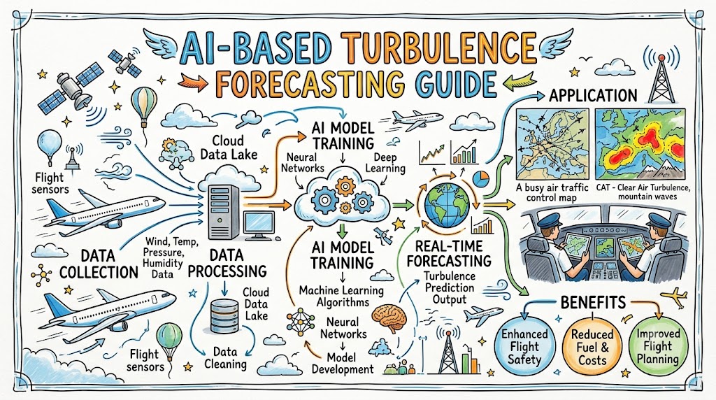
A practical AI forecasting system may follow the process below.
Step 1: Collect Weather and Flight Data
The system gathers information from aircraft sensors, weather models, satellite observations, radar networks, operational databases, and reported turbulence encounters.
Step 2: Clean and Standardize the Data
Data may arrive in different formats, units, time intervals, and quality levels. Invalid, duplicated, incomplete, or inconsistent records must be identified.
Aircraft identities or sensitive operational information may also need to be removed or protected.
Step 3: Match Conditions With Turbulence Observations
The system connects actual turbulence observations with the atmospheric conditions that existed at the same location, altitude, and time.
This creates examples from which the model can learn.
Step 4: Create Predictive Variables
Developers may convert raw data into useful variables such as:
- Vertical wind shear
- Horizontal wind deformation
- Atmospheric stability
- Temperature gradient
- Distance from a jet-stream core
- Storm proximity
- Terrain interaction
- Recent EDR observations
- Rate of storm growth
Step 5: Train the Model
The algorithm studies historical examples and learns which combinations of variables are associated with smooth, light, moderate, or stronger turbulence.
Step 6: Validate the Forecast
The model is tested on data it did not use during training. Developers examine missed events, false alarms, reliability, geographic performance, and performance at different altitudes.
Step 7: Generate a Forecast
The operational system may produce:
- A turbulence probability
- An expected EDR range
- A confidence level
- A geographic hazard area
- An altitude-specific forecast
- A suggested time window
Step 8: Deliver Information to Users
Results may appear in a dispatch platform, weather viewer, operations-control system, electronic flight bag, or compatible cockpit weather application.
Step 9: Compare Forecasts With New Observations
New aircraft measurements and pilot reports help determine whether the forecast was correct.
Step 10: Improve the System
Models may be retrained or recalibrated as additional data becomes available. Changes must be controlled, documented, tested, and validated before operational use.
Data Used in AI Turbulence Forecasting
The quality of an AI forecast depends heavily on the information supplied to it.
Aircraft-Based Observations
Modern aircraft can report several useful meteorological measurements, including:
- Air temperature
- Wind speed
- Wind direction
- Pressure altitude
- Turbulence measurements such as EDR
Commercial aircraft can therefore serve as platforms for collecting meteorological data during normal operations.
Numerical Weather Model Data
Weather models provide three-dimensional information across wide areas, including regions where few aircraft are currently flying.
The model may use forecasts of wind, temperature, pressure, humidity, vertical velocity, and atmospheric stability.
Satellite Information
Satellites provide broad geographic coverage and can observe cloud development, moisture patterns, atmospheric temperature, and convective activity.
Deep-learning systems can process several satellite channels at once and identify visual patterns connected with turbulence.
Radar Data
Radar information helps identify precipitation intensity, storm structure, movement, and convective development.
Radar-derived information is particularly valuable for turbulence associated with thunderstorms and strong convection.
Historical Flight Data
Historical flight records may show where turbulence occurred, what the surrounding atmosphere looked like, and how different aircraft responded.
This information can support model training, but it must be handled with strong governance, privacy protection, and quality controls.
Pilot Reports
PIREPs continue to provide valuable operational context. However, AI systems must account for variations in wording, aircraft type, reporting habits, and timing.
AI and Machine-Learning Technologies Used
Several AI techniques can support turbulence forecasting.
Supervised Machine Learning
Supervised learning uses examples with known results. The model receives atmospheric data along with confirmed turbulence observations and learns the relationship between them.
Regression Models
Regression estimates a numerical value, such as predicted EDR.
This can provide more detail than a simple smooth-or-turbulent classification.
Decision Trees and Random Forests
A decision tree divides data according to conditions such as wind shear, altitude, temperature gradient, or storm proximity.
Random forests combine many decision trees and can identify complex patterns across large aviation weather datasets.
Neural Networks and Deep Learning
Neural networks can learn complex relationships between many variables.
Deep-learning architectures may be useful when processing satellite images, radar fields, three-dimensional weather grids, or large sequences of flight observations.
Data Fusion
Data fusion combines information from several sources.
For example, an AI system may compare a numerical model forecast with recent EDR measurements, satellite imagery, storm data, and nearby flight reports.
Real-Time Processing
A forecast loses operational value when it arrives too late. Real-time systems must collect, process, validate, and distribute data quickly enough to influence decisions.
Explainable AI
Explainable AI methods help users and developers understand why a model produced a certain result.
In aviation, explanation and traceability can be important because a forecast may influence route planning, altitude selection, fuel decisions, and cabin preparation.
Traditional Forecasting Versus AI-Based Forecasting
| Comparison Area | Traditional Forecasting | AI-Based Forecasting |
|---|---|---|
| Data volume | Uses selected weather products and established diagnostics | Can process large and diverse datasets simultaneously |
| Forecast method | Relies on physical models, rules, and expert interpretation | Learns statistical patterns from historical and real-time data |
| Update speed | Depends on product cycles and reporting frequency | May update rapidly when connected to live data |
| Pattern recognition | Strong when atmospheric relationships are well understood | Can identify complex nonlinear relationships |
| Clear-air turbulence | Uses wind, stability, and turbulence diagnostics | Combines diagnostics with aircraft observations and learned patterns |
| Human involvement | Requires meteorologist, dispatcher, and pilot interpretation | Still requires professional review and operational judgment |
| Consistency | Based on standardized methods and procedures | Depends on model design, training data, and validation |
| Explainability | Often easier to connect with known atmospheric physics | Some models may be difficult to interpret |
| Scalability | Can cover large areas through numerical models | Can process global data but needs significant infrastructure |
| Main limitation | Forecast resolution and atmospheric uncertainty | Data bias, false alerts, model drift, and integration challenges |
The strongest operational approach is not necessarily traditional forecasting versus AI. It is the careful combination of physical weather science, automated guidance, machine learning, real observations, and human expertise.
Benefits of AI-Based Turbulence Forecasting
Earlier Warnings
AI may identify developing risk before a flight reaches the affected region, giving pilots and dispatchers more time to evaluate alternatives.
Better Altitude Planning
Turbulence can be concentrated within a particular altitude range. More detailed forecasts may help crews determine whether climbing or descending could provide smoother conditions.
Any altitude change still requires aircraft-performance review and air traffic control clearance.
Improved Cabin Safety
Earlier information gives pilots more time to illuminate the seat-belt sign, stop cabin service, secure equipment, and ask cabin crew members to take their seats.
More Comfortable Flights
Avoiding unnecessary exposure to turbulent areas may improve passenger comfort and reduce disruption to cabin service.
Better Operational Coordination
Dispatchers, meteorologists, pilots, and operations-control teams can work from a shared turbulence picture.
More Efficient Decision-Making
Accurate turbulence information may reduce unnecessary route deviations or precautionary altitude changes. However, efficiency benefits depend on airspace, traffic, fuel, weather, and aircraft-performance constraints.
Modern turbulence platforms can consolidate, standardize, deidentify, and share airline turbulence data so that it can be integrated into operational and flight-planning tools.
AI Forecasting During Pre-Flight Planning
Before departure, the dispatcher and flight crew can review turbulence risk along the proposed route.
They may examine:
- Expected turbulence location
- Forecast altitude range
- Time of expected activity
- Convective weather
- Jet-stream position
- Mountain-wave conditions
- Recent aircraft reports
- Possible route alternatives
- Fuel implications
- Suitable alternate airports
- Aircraft performance
- Cabin-service planning
Pre-Flight Turbulence Assessment Checklist
- Review official aviation weather forecasts.
- Check significant weather advisories.
- Examine turbulence guidance at planned cruise levels.
- Review recent PIREPs and objective EDR observations.
- Identify thunderstorms and convective areas.
- Check jet-stream and wind-shear patterns.
- Consider terrain and mountain-wave risk.
- Compare the primary route with practical alternatives.
- Calculate the fuel effect of possible deviations.
- Brief cabin crew about expected conditions.
- Confirm how updated weather will be received in flight.
- Establish clear decision points for route or altitude changes.
AI Forecasting During Flight
Atmospheric conditions can change after departure, so pilots need updated information.
Real-Time Alerts
Connected systems may display recent turbulence observations or updated forecasts along the planned route.
The crew should check:
- The age of the report
- The reporting altitude
- The source of the information
- The forecast confidence
- The aircraft type associated with a subjective report
- Whether the hazard is moving or developing
Altitude and Route Changes
When turbulence is expected, pilots may request a different altitude or heading.
Before changing altitude, they must consider traffic separation, fuel, winds, aircraft performance, weather above and below, and air traffic control instructions.
Cabin Preparation
A forecast can support an earlier decision to:
- Switch on the seat-belt sign
- Stop cabin service
- Secure carts and equipment
- Ask passengers to return to their seats
- Have cabin crew members sit down
- Provide a calm passenger announcement
Communication With Other Aviation Professionals
Pilots can coordinate with:
- Air traffic controllers
- Airline dispatchers
- Operations-control personnel
- Cabin crew
- Other aircraft through pilot reports
The pilot in command remains responsible for the safe operation of the flight.
Airline Integration of Turbulence Forecasting
An airline can integrate turbulence information into several systems.
Flight-Planning Platform
Forecast turbulence can be displayed along potential routes and altitude profiles.
Operations Control Centre
Dispatchers and meteorologists can monitor the fleet and warn flights approaching a developing hazard.
Electronic Flight Bag
Approved applications may provide graphical weather and turbulence information to pilots.
Safety Management System
Post-flight turbulence reports can be reviewed to identify recurring routes, seasons, operational risks, and procedural improvements.
Training Programmes
Actual events can be converted into flight-crew, dispatcher, and cabin-crew training scenarios.
A Practical Airline Workflow
- Weather and aircraft data enter the forecasting system.
- The system estimates turbulence probability and intensity.
- A quality-control process checks the information.
- The forecast appears in the airline’s operational platform.
- A dispatcher reviews flights that may be affected.
- The dispatcher shares relevant information with the crew.
- The crew compares the alert with onboard weather and operational conditions.
- The pilot decides whether an action is necessary.
- The aircraft records or reports actual conditions.
- The observation returns to the data system for analysis.
Challenges and Limitations
AI-based forecasting has significant potential, but it also has important limitations.
Incomplete Data Coverage
Some regions have more aircraft observations, radar coverage, or communication infrastructure than others.
A model trained mainly on data from busy routes may perform differently over oceans, remote terrain, or areas with limited observations.
False Alerts
A model may forecast turbulence that does not occur. Frequent false alerts can cause unnecessary deviations, increased fuel use, and reduced trust.
Missed Events
A system may fail to predict an actual encounter. This is why crews must continue monitoring weather, aircraft instruments, and operational reports.
Rapid Atmospheric Change
Thunderstorms and local atmospheric disturbances can develop quickly. A forecast based on older data may no longer represent current conditions.
Aircraft Differences
The same atmospheric turbulence can produce different effects on different aircraft. Weight, speed, configuration, loading, and control response all influence how turbulence feels.
Model Bias
A model learns from its training data. Missing regions, altitudes, aircraft categories, or weather types can create uneven performance.
Limited Explainability
A complex neural network may produce an accurate forecast without providing a simple explanation. This can make validation and operational trust more difficult.
Cybersecurity and Privacy
Aircraft and airline operational data must be protected against unauthorized access, manipulation, and misuse.
Integration Costs
Airlines may need new software, data agreements, connectivity, training, maintenance, cybersecurity controls, and approval processes.
Model Drift
Atmospheric datasets, sensors, operational practices, and data sources can change. Performance must be monitored after deployment.
Human Expertise and Pilot Decision-Making
AI cannot see every operational factor affecting a flight.
A forecast model may not fully understand:
- The aircraft’s technical condition
- Current traffic restrictions
- Crew workload
- Passenger medical concerns
- Cabin-service status
- Airspace closures
- Company procedures
- Real-time visual observations
- Aircraft handling response
- The availability of alternative altitudes
Meteorologists understand atmospheric processes. Dispatchers understand route, fuel, airport, and operational constraints. Air traffic controllers manage separation and traffic flow. Pilots observe the actual aircraft response and make operational decisions.
AI should support this team rather than replace it.
A safe decision may sometimes mean avoiding a forecast area. In another situation, it may mean maintaining the route while preparing the cabin. The correct action depends on the complete operational picture.
Safety, Regulation, and Data Governance
An aviation AI system should not be introduced only because it performs well in a laboratory test.
Operational use requires attention to:
- Data accuracy
- Software assurance
- System reliability
- Human factors
- Cybersecurity
- Failure procedures
- Forecast traceability
- User training
- Performance monitoring
- Model-change control
- Regulatory requirements
- Clear operational responsibility
The interface must also communicate uncertainty clearly. A pilot needs to know whether a displayed area represents an observation, a forecast, a probability, an advisory, or a combination of sources.
Data should be protected through access controls, deidentification, secure transmission, retention policies, and controlled sharing.
Fictional Flight Scenario
The following example is fictional and provided only for education.
A commercial flight is scheduled from Delhi to Frankfurt. The planned cruise altitude is 36,000 feet.
During pre-flight planning, conventional weather products show a strong upper-level jet stream along part of the route. No major thunderstorm directly blocks the flight path, but the atmosphere contains strong wind gradients.
An AI-enhanced turbulence system examines numerical weather data, recent EDR observations from other aircraft, satellite information, wind shear, and historical atmospheric patterns.
The system identifies an increased probability of moderate clear-air turbulence between 34,000 and 38,000 feet during the estimated time of passage.
The dispatcher reviews the alert and compares it with official weather guidance and recent pilot reports. The dispatcher and captain discuss two options:
- Remain on the planned route but request a lower cruise level before reaching the area.
- Make a small route adjustment around the highest forecast risk.
Fuel, airspace, winds, and aircraft performance are reviewed. The crew decides to continue on the planned route while requesting 32,000 feet before reaching the affected region.
Air traffic control approves the descent. The captain briefs the cabin crew early, suspends service, and asks passengers to keep their seat belts fastened.
The aircraft experiences only light turbulence at the lower altitude. After passing the area, the crew climbs to a more efficient cruise level.
The positive outcome did not come from AI alone. It resulted from combining forecast information, official weather products, dispatcher analysis, pilot judgment, air traffic control coordination, and cabin preparation.
The Future of AI-Based Turbulence Forecasting
The next generation of forecasting may combine more aircraft observations with faster weather models and improved communication.
Possible developments include:
Larger Aircraft Data Networks
More connected aircraft could provide denser EDR, wind, and temperature observations.
Near-Time Predictive Systems
Current observations may be combined with AI to predict how turbulence areas will develop or move ahead of an aircraft.
Better Oceanic Coverage
Oceanic areas generally have fewer ground-based observations. Satellite communication and aircraft-based reporting may improve coverage.
Advanced Satellite Analysis
AI may process multispectral satellite data to identify subtle patterns associated with convection, moisture, temperature, and atmospheric instability.
Improved Weather Models
Higher-resolution models may represent smaller atmospheric features more effectively, although uncertainty will remain.
Aircraft-to-Aircraft Information Sharing
Nearby aircraft could contribute observations to a shared operational picture, subject to approved technology and data standards.
More Personalized Operational Guidance
Future systems may account for aircraft type, weight, route, altitude, and predicted atmospheric state when presenting decision-support information.
These developments should not be presented as fully mature or universally available. Capabilities vary among airlines, aircraft, software providers, and regions.
Skills Aviation Students Should Learn
Students interested in AI-based aviation systems should build knowledge across aviation, meteorology, and data science.
Important learning areas include:
- Aviation meteorology
- Types and causes of turbulence
- Weather-chart interpretation
- Flight planning
- Aircraft performance
- Human factors
- Safety management systems
- Basic statistics
- Machine-learning concepts
- Data quality and validation
- Digital cockpit systems
- Cybersecurity awareness
- Risk-based decision-making
- AI ethics and governance
A student does not need to become both a professional pilot and an AI engineer immediately. However, understanding how these disciplines connect can create valuable career opportunities in airline operations, aviation software, safety analytics, meteorology, research, and autonomous flight-support technology.
AI Aviation Academy can use topics such as turbulence forecasting to help learners connect artificial intelligence with real aviation problems rather than studying AI only as an abstract technical subject.
Best Practices for Using AI Turbulence Forecasts
- Use AI forecasts as decision-support information.
- Compare them with official aviation weather products.
- Check the issue time and validity period.
- Review the forecast altitude carefully.
- Distinguish observations from predictions.
- Understand the displayed probability or confidence.
- Check recent PIREPs and objective EDR reports.
- Consider aircraft size, weight, and performance.
- Monitor onboard weather systems continuously.
- Coordinate with dispatch and air traffic control.
- Prepare the cabin before reaching the hazard.
- Follow airline procedures and operational limitations.
- Report significant turbulence encounters accurately.
- Record false alerts and missed events for system review.
- Never assume that a forecast guarantees smooth conditions.
Frequently Asked Questions
What is AI-based turbulence forecasting?
AI-based turbulence forecasting uses machine-learning methods to analyse weather, aircraft, satellite, radar, and historical data. It estimates where and when turbulent conditions may occur.
Can artificial intelligence accurately predict turbulence?
AI can improve pattern recognition and combine more data than a person could examine manually. However, atmospheric uncertainty, limited observations, and rapidly changing weather prevent perfect prediction.
Can AI detect clear-air turbulence?
AI can estimate the probability of clear-air turbulence using wind shear, jet-stream patterns, atmospheric stability, numerical weather models, and aircraft observations. It cannot guarantee detection of every event.
What data is used to forecast turbulence?
Typical inputs include wind, temperature, pressure, humidity, satellite imagery, radar data, numerical weather forecasts, aircraft position, altitude, EDR measurements, and pilot reports.
What is EDR?
Eddy Dissipation Rate is an objective measure of atmospheric turbulence intensity. It helps standardize turbulence observations across different aircraft and reporting systems.
Do pilots receive AI turbulence alerts in real time?
Some airlines and cockpit applications provide updated turbulence information. Availability depends on the airline, aircraft, connectivity, software integration, regulatory requirements, and region.
Can AI prevent all turbulence encounters?
No. AI can support earlier warnings and better planning, but it cannot remove atmospheric uncertainty or prevent every encounter.
Is AI replacing aviation meteorologists?
No. Meteorologists remain necessary for interpreting atmospheric processes, validating forecasts, evaluating uncertainty, and supporting operational decisions.
How can turbulence forecasting improve passenger safety?
Earlier warnings allow pilots to activate the seat-belt sign, stop cabin service, secure equipment, and seat cabin crew before the aircraft reaches a turbulent area.
Can turbulence forecasts help airlines save fuel?
More precise information may help airlines avoid unnecessary deviations or altitude changes. Actual fuel savings depend on route, winds, traffic, aircraft performance, airspace, and forecast accuracy.
What are the main limitations of AI turbulence prediction?
Major limitations include incomplete data, false alerts, missed events, geographic bias, rapid weather changes, limited explainability, cybersecurity concerns, and differences among aircraft.
Will future aircraft automatically avoid turbulence?
Future flight-support systems may provide more advanced route and altitude recommendations. Fully automatic avoidance would require reliable data, safe system design, air traffic coordination, regulatory approval, and appropriate human oversight.
Conclusion
AI-based turbulence forecasting combines aircraft observations, numerical weather models, radar, satellite information, historical records, and machine learning to provide a more detailed picture of potential turbulence. Its greatest value comes from supporting, rather than replacing, pilots, meteorologists, dispatchers, cabin crews, and air traffic controllers. When advanced forecasting is combined with reliable data, official weather products, sound procedures, early cabin preparation, and professional judgment, aviation teams can make better-informed decisions for safer and more comfortable flights. AI Aviation Academy can help learners understand these emerging systems and prepare for a future in which aviation knowledge and artificial intelligence increasingly work together.